
The city
The Vltava in Prague: the river the city keeps arguing with
Tony Denesa – Travel Advisor9 min read
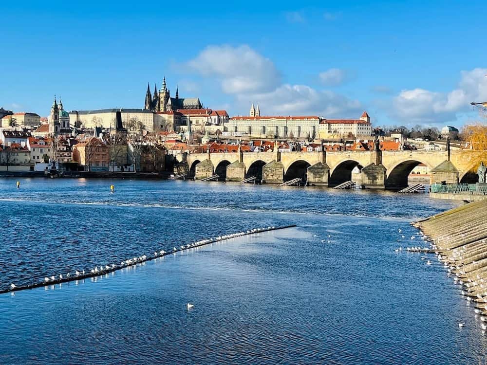
Prague without the Vltava is not a thinkable city. The Castle is on one bank because the Old Town is on the other; the Charles Bridge exists because a king needed the two halves stitched together; and the single most famous piece of Czech music — Smetana's *Vltava*, from *Má vlast*, 1874 — is a portrait of this river arriving at this city.
The Vltava is the longest river in Czechia, around 430 kilometres from its sources in the Šumava forest near the Austrian border to its confluence with the Elbe at Mělník, half an hour north of Prague. The name is old Germanic in origin — something close to *wild water* — which reads as irony today and was not one for most of the city's history.
Through the centre it runs roughly 300 metres wide, shallow, and stepped by weirs, which is why it looks so calm. The calm is engineered.
The bridge before the bridge
The first stone crossing was the Judith Bridge, built in the twelfth century and named for the queen who sponsored it. It stood for about 170 years, until the flood of February 1342 tore it down — ice and high water, the combination that has destroyed more of Prague than any army has.
Its replacement is the one you know. Charles IV laid the foundation stone of the Charles Bridge on 9 July 1357 — by tradition at 5:31 in the morning, so that the date and time formed a palindrome of odd numbers, 1357 9/7 5:31, chosen by court astrologers. Whether the story is true, the bridge has needed the luck: the flood of September 1890 brought three of its arches down, and logs from broken timber rafts battered the piers for days.
His building programme can still be read in stone, most famously on Charles Bridge.
2002, the flood that is still the reference point
Every generation of Prague gets a flood, and the one that defines the present city came in August 2002. After weeks of rain across Bohemia, the Vltava peaked in Prague at around 5,300 cubic metres per second — against a normal late-summer flow of about 150 — a level the hydrologists called a 500-year event.
Kampa Island went under. The metro flooded through its own tunnels, putting stations out of action for months. Worst hit was Karlín, the low-lying nineteenth-century district downstream of the centre, where the water stood roughly three metres deep in the streets and some buildings later had to be demolished.
The strangest chapter happened at the zoo in Troja, which sits on the flood plain: animals were evacuated up the hillside, the elderly elephant Kadir could not be moved and was put down as the water rose, and Gaston the sea lion escaped into the river and swam all the way into Germany before being recaptured — a national news story with an unhappy ending, as he did not survive the journey back.
Karlín's rebuilding turned it from a byword for decay into one of the best districts in the city to eat and drink in, which nobody would have predicted in September 2002. The city also built a system of mobile flood barriers afterwards — aluminium walls that go up along the embankments when the gauges upstream say so. They were used in earnest in June 2013, when the river flooded again, and held.
Weirs, dams and why the river behaves
The stillness of the water under the Charles Bridge is the work of the weirs — low angled dams that step the river down through the city. The Old Town weir beside the bridge, with its wooden icebreakers, appears in every second photograph of Prague without being noticed; canoeists run the chute at its end all summer.
The bigger control is invisible from town: the Vltava Cascade, a chain of dams built upstream mostly in the 1950s and 60s — Lipno, Orlík, Slapy and others — which generates power, feeds reservoirs and evens out the flow. It cannot stop a 2002, as 2002 demonstrated, but it is the reason an ordinary spring no longer threatens the city the way it did for centuries.
Commercial navigation is modest — tour boats, a little freight — passing the weirs through locks on the Smíchov side.
The islands
Kampa is the famous one, and is barely an island at all: the Čertovka, the „Devil's Stream", a mill channel dug in the Middle Ages, separates it from Malá Strana. It has the Lennon Wall at its edge, the Museum Kampa in a converted mill on the waterfront, and the best lawn in central Prague.
Slovanský ostrov holds the Žofín palace, a nineteenth-century ballroom where Berlioz and Liszt performed; rowing boats and pedalos are hired from its tip, and paddling one under the National Theatre at dusk is the cheapest romantic gesture in the city.
Střelecký ostrov — Shooters' Island, once a marksmen's practice ground — hangs under the Legion Bridge, half-wild, with a summer bar and the best low-angle view of the Charles Bridge.
Štvanice, upstream between Holešovice and Karlín, is the sports one; Císařský ostrov, further down by Troja, is where the city walks its dogs.
Náplavka
The embankment between the railway bridge at Výtoň and Palacký Bridge — Náplavka — is the river's social contract with the present city. Saturday mornings it is the best farmers' market in Prague; summer evenings it is one long bar, with the converted river-wall vaults — the *kobky* — housing galleries and cafés, and swans negotiating for chips at the water's edge. It sits below Vyšehrad, so the classic move is the rock first, the embankment after.
Reading the bridges
Eighteen road and rail bridges cross the Vltava in Prague. The ones worth knowing by name, going downstream: the railway bridge at Výtoň (1901, riveted iron, a listed monument the city keeps arguing about repairing); Palacký Bridge; the Legion Bridge, whose stone came from the same quarry family as the National Theatre beside it; the Charles Bridge; Mánes Bridge by the Rudolfinum; and the Art Nouveau Čech Bridge of 1908, the shortest and the prettiest, aimed straight at the Letná hill.
The view that organises all of them is from the Letná beer garden above the north bank: five bridges in one frame, which is the picture the postcards mean when they say Prague.
Swimming, and where people actually do it
Not in the river, mostly — the weirs, the boat traffic and the cold make the channel itself a bad idea. Where the city swims is the Podolí lido complex just upstream of Vyšehrad, and at Žluté lázně further along the same bank, a riverside beach club that has run in some form since the First Republic. The Vltava in the centre is for looking at, rowing on, and drinking beside — a division of labour the city settled long ago.
Where to stay nearby
Live prices and availability on a map centred on this exact spot — hotels, apartments and hostels, so you can judge the walk from here rather than guess from an address.
Bookings made through this map earn us a commission. Your price is unaffected.